These two peaks, normally done together with Gunung Charlie and Yong Belar is known as the YB3B.
However this time round we are just attempting Gunung 6040m and Gunung Tiga Negeri. These twin peaks hike is around 20km covering secondary dipterocarp forest (Meranti, Balau, Kapur, Chengal, Keruing) montane #mossyforest and ericaceous forest. The hike is long and arduous, and if the weather conditions go against you, you'll be hiking in the dark! Come mentally prepared!
The mossy forest in this mountain is extensive and untouched. To walk in this forest feels surreal and out of the world. It is worth every muscle ache!
Part 1: Gunung 6040, 1840m
Mount 6040 got its name literally from its height in feet! From the greenhouse to the peak, takes around 4 hours, about 7km one way. The terrain encompasses muddy trails, soft mossy loose soil, wet puddles, loose gravel, narrow and low trees and trunks and some steep inclines! Although the total elevation gain is only 750m, the hike is indeed long.
Starting point: Trailhead from Vegetable Farm,
In the past, 4x4 used to transport hikers right up to the trailhead but due to overexploitation of farmland, hikers now need to make an extra 3km hike to the trailhead.
Hike Duration: 10-12 hours depending on fitness and weather conditions
Total Distance: 20km to and fro
End Hike: Backtrack
Hike Difficulty: Medium to Hard, Not Suitable for Newbies and children!
Scenery Rewards: Enchanting Mossy Forest
Leech: NONE
Parking: By the road leading to the farm
What to bring
headlamps, absolutely necessary
change of clothes, towel, jacket in the car
raincoat
hiking stick
whistle
2.5 litres of water
good pair of hiking shoes
lunch and a snack!
Thermal blankets in the car
Tips: It will most probably rain in the afternoon, start early and avoid rainy conditions.

Getting lost in the labyrinth and overhangs of dense moss, lichens, pitcher plants, & orchids feels like a set from enchanting middle earth!
Stage 1 : Through the Greenhouse
This 1 km walk towards the trailhead through the hydroponic greenhouse is uninteresting and flat with periodic potholes and broken pipes along the sides. The path ends at a bend, with a mountain on the left. Continue along the path to the forest.


Stage 2: Pipe Area
From here, the path ascends gradually over 2.5km. You will walk through the secondary forest, laden with pipes that supply water to the hydroponic farms.
Occasionally some of these pipes puncture causing water to spray out! Try not to step on them as they are slippery and have no grip!
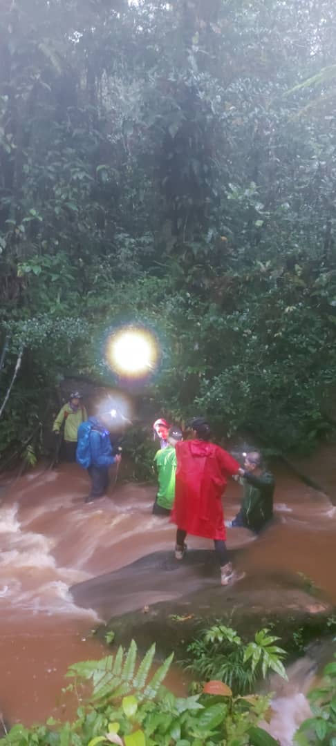
This path has 3 river crossings. You may get your feet wet if the water level is high, but for your mental comfort, keeping your feet dry at the beginning of an epic 20km hike, is affirmative! The trail follows the stream uphill.

On the return leg, the stream quickly change into a ferocious gushing river! The currents started to stir and the water level rose very rapidly.
Stage 3: Enchanting Mossy forest
At this stage, you will be hiking on the borders of Perak and Kelantan and Pahang along the way. The inclines are gradually steeper here.


boarder stones of Perak, Kelantan, Pahang along the 2.5km trail
the tree species changes as you ascent

This stretch of the mossy forest will strike you with awe and at the same time, the low overhangs and stunted trees will require a lot of acrobatic skills as you squeeze your way through some narrow and low parts!
You'll hardly notice the fatigue as you are overwhelmed by the magical landscape. But on the return leg, it will take a toll.

Along the final stretches towards 6040m peak, the mossy forest is most intense but be wary not to spend too much time here!
Stage 4: Gunung 6040

Part II Gunung Tiga Negeri /Mount Three Boundaries
The hike to Mount 3 boundaries is about 2.5km. The terrain is a mixture of mossy forest, decent to a gully on muddy soil, ascent towards mossy land and through the mountain ridge of bushes towards the unobstructed panoramic views of 3 boundaries point!
At some point on the ridge, I was wondering if I would ever reach the peak of 3 boundaries, feelings of desperation begin to sweep in! I kept yelling out at the hikers ahead for motivation and answers, and thankfully, there was a reply!

This journey is challenging and takes about 1 and half hours without break. But the panoramic view at Gunung 3 Negeri is rewarding. However, if you feel drained at this point, you don't have to proceed!

Mount 3 boundaries of Perak, Kelantan and Pahang 1764m

The panoramic scenery here is incredible, with full views of some of the highest mountains of the Titiwangsa! Remember not to spend too much time at the peak, as the return leg will take 4-5 hours depending on weather conditions.
Return Leg
It is absolutely important to save some water supply and snacks on the return leg. A whopping 9km to the car park will drain up all your remaining strength and energy, and hopefully, you won't need to navigate in the dark!
Exhausted and fatigued, among us, a hiker had to moan each time he crawled over a tree or a log. The weather conditions deteriorated quickly as we left the peak. The heavens opened and it started pouring. The loose earth became puddles of muddy and wet terrain. The mossy forest became a wet sponge filled with water and the trail, more slippery.
It became dark and navigating in the forest got harder and confusing. Our shoes were soaking wet more than halfway down the mountain! In moments like this, be warned never to take this hike alone! We were fortunate to get out before dark because of the great camaraderie of the group. We helped and supported each other across the roaring river and all the way to the restaurant!
Habitats
The pitcher traps on Mount 6040 peak are huge. The Nepenthes Rajah usually holds up to 2 litres of liquid, but some exceptional plants can reach a volume of up to 2-3 litres of water. The King of Nepenthes traps not only insects, but also small animals like rats, shrews, lizards, and birds!


There were many orchid species perched on every branch in the mossy forest. The greatest number of orchid species is found in cloud-forest!

Reflections
This hike was arranged by My Back to Nature. It is necessary to apply for permits and guides for this hike. This is an epic hike and definitely requires some experience and mental preparation! Please don't come here thinking it is an urban Kiara hike!

We were unlucky with the weather. Most of us were exhausted, wet and cold. And some had little choice but to continue the gruelling march out in the dark! There were many unsung heroes in the group that stood out as beacons to guide everyone out to safety, unscathed, just chilled from the wet Cameron Highlands climate! Thank you all!
Date visited: 21st November 2021
Photo credits: Contributions from all the brilliant photographers of the hiking group!


Comments